|
|
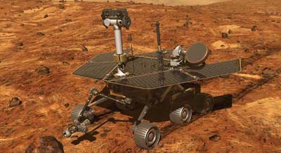
 Illustration of a Mars Exploration Rover on the surface of Mars. (credit: NASA/JPL) |
The search for water: picking landing sites for NASA’s Mars rovers
by Henry Bortman
Monday, April 7, 2003
[Editor’s Note: This article originally appeared as a pair of articles published last month by Astrobiology Magazine, and is reprinted here with the kind permission of Astrobiology Magazine.]
“Follow the water” is the mantra for NASA’s Mars exploration program. But present-day Mars is so cold, and its atmosphere so thin, that liquid water cannot exist on the planet’s surface. What NASA can look for, though, is evidence that water was present and active on Mars in the distant past. There are strong indications, in images taken by cameras aboard orbiting spacecraft, that features of the Martian landscape have been carved by water. But some scientists argue that these features could have been caused by short-lived torrents of water—flash floods.
More interesting, because the ultimate goal of Mars exploration is to look for signs of life, would be to find areas where water flowed over long periods of time, either continuously or episodically; or where water ponded for long periods of time, such as in a lake. Convincing evidence for long-term water activity is difficult to nail down with photographs taken from orbit, however. That’s the job of landers and rovers, like the rovers NASA plans to send to Mars later this year.
The upcoming missions are referred to as MER A and MER B—MER stands for Mars Exploration Rover—and, yes, it’s missions, plural. MER A will launch in late May or June, MER B in June or July. Both rovers will touch down on Mars in January 2004. The MERs are equipped with a host of instruments designed to investigate the mineral compositions of rocks nearby the landing sites. By studying mineral compositions, scientists will be able to learn a great deal about how the rocks were formed, particularly what role water played in their formation.
| By studying mineral compositions, scientists will be able to learn a great deal about how the rocks were formed, particularly what role water played in their formation. |
Only once before has NASA sent a spacecraft to Mars capable of roaming about on the surface. Pathfinder, which arrived on July 4, 1997, carried within it a small rover, Sojourner. For all the excitement Sojourner generated, it traveled a grand total of about 100 meters before its mission was terminated.
The MERs are larger than Sojourner, contain more advanced scientific instruments and can travel farther—up to half a kilometer (just under one-third of a mile). But just where on Mars is the best place to “follow the water”? Although Mars’s diameter is only about half that of our home planet, it has as much surface land mass as Earth—because it’s all land mass. That’s a lot of real estate to choose from.
Two landing sites, very different from each other, are the leading candidates. One, in Meridiani Planum (formerly referred to as Terra Meridiani), is notable because it contains a large deposit of gray hematite, an iron-rich mineral that on Earth is usually formed by the long-term action of water. The other, Gusev Crater, is intriguing because it appears to be the site of an ancient lakebed, where layers of sediment were deposited by a long-term flow of water into the basin formed by the crater.
page 2: hematite, water, and life >>
|
|
